Two Severn River lots can share the same asking price yet differ by seven figures in real value. If you are weighing a waterfront purchase or preparing to sell, it helps to see the river the way seasoned local experts do. In this guide, you will learn which attributes consistently drive price, how regulations shape what you can build or improve, and the due diligence steps that keep costly surprises off your balance sheet. Let’s dive in.
The Severn’s core value drivers
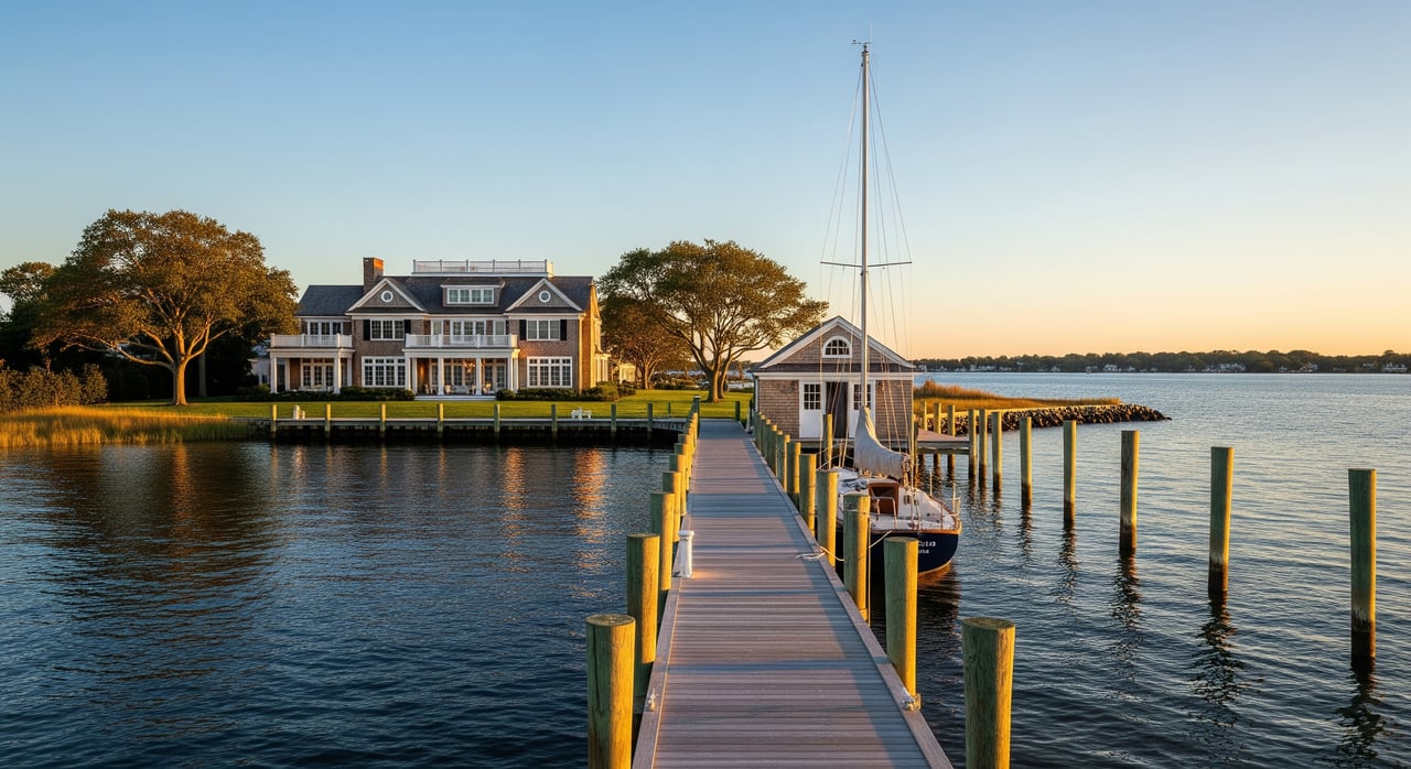
Shoreline frontage and how it is measured
Waterfront is often priced by the linear foot, but not all frontage is equal. Linear footage must be defined precisely, typically using a recorded deed, plat, or survey that shows the mean low water or mean high water line. On tidal water like the Severn, only a current survey will confirm the legal shoreline boundary.
Usable frontage matters more than raw length. A shorter stretch of well-protected, deep-water shoreline can outvalue a longer run of shallow, marshy edge. Appraisers and brokers adjust price per foot based on depth, actual dock utility, shoreline protection, and what the local cove’s recent sales support.
Mean low water depth and draft
Mean low water depth controls which vessels can reach a dock at low tide. If you own or plan to own a deep-draft sailboat or a large motor yacht, the usable depth at the dock face is a gating factor. Public charts and marina guides provide a general picture, but only a site-specific marine sounding confirms the depths that matter for your boat and crew.
Depth is dynamic. Tidal currents, shoaling, and seasonal sedimentation can reduce effective depth over time. If dredging is part of your plan, build in permitting, cost, and maintenance cycles from the start.
Protection, orientation, and views
Protected coves or locations tucked behind points or shoals tend to offer calmer water, smaller wave fetch, and smoother docking. Buyers often pay a premium for that protection. Orientation adds lifestyle value. South or west exposure can deliver longer light and better sunsets, while open views to the main river or the Bay can heighten the daily experience. Exposure to prevailing winds or heavy fetch can suppress value unless you have strong stabilization and dock design.
Privacy, acreage, and buffers
Large parcels with long setbacks, mature tree canopy, and topography that screens neighbors are scarce along the Severn. That scarcity drives premiums for estate-scale properties. Vegetated buffers and natural shorelines also appeal for environmental reasons. Keep in mind that the Maryland Critical Area program and any conservation easements can shape what you can clear or build.
Proximity and access by water and road
Time to Annapolis Harbor and the Chesapeake Bay is a quality-of-life metric that shows up in pricing. Shorter boat runs to restaurants, yacht clubs, fuel, and the downtown waterfront are valued by active boaters. On land, access to Annapolis, major routes like US-50 and MD-2/MD-450, regional airports, schools, and medical facilities supports the daily utility of a waterfront estate. Certain Severn addresses and view corridors carry prestige that can lift prices beyond pure physical specs.
Regulations that shape what you can do
Shoreline boundaries and riparian rights
On tidal waters in Maryland, a recorded deed and survey will show whether your boundary follows mean low or mean high water. Confirm riparian rights for dock access and check for any encroachments or easements. Work with a licensed surveyor and an attorney experienced in Maryland riparian issues to validate the property’s rights before you price, list, or offer.
Permits and agencies to know
Shoreline work sits within a layered framework. The Maryland Department of the Environment issues permits for shoreline stabilization, tidal wetlands impacts, and dredging. The Maryland Department of Natural Resources oversees tidal wetlands protections, submerged aquatic vegetation, and boating infrastructure rules. The U.S. Army Corps of Engineers governs structures seaward of mean high water and dredging. Anne Arundel County and the City of Annapolis implement Critical Area and zoning rules, while FEMA flood maps and base flood elevations drive insurance and elevation requirements.
Environmental limits and long-term risk
Submerged aquatic vegetation, intertidal marsh, and shellfish areas can require longer or elevated piers and can limit placement. Dredging often needs periodic maintenance and renewed permits, which adds cost and timing risk. The Severn is tidal, so nuisance flooding and storm surge are part of long-term planning. Insurers and sophisticated buyers price sea-level rise and hazard mitigation into decisions, so review county and city studies and align design choices accordingly.
Bulkheads and shoreline infrastructure
A failing bulkhead is a near-term capital expense and a negotiating flashpoint. Replacement costs, permit complexity, and the engineering required to stabilize a site should be reflected in valuation. Inspect every dock, pier, and bulkhead with a qualified engineer or contractor so you know what you are actually buying or selling.
Large-yacht lifestyle factors
Dock design and depth for big vessels
For large yachts, deep-water dockage is the centerpiece. Buyers look for adequate MLW depth, robust structures, ample shore power, and fueling and tender logistics that make arrivals and departures routine. The best waterfront is turnkey for crews and guests.
Service and haul-out access
Evaluate how easily a vessel can access capable shipyards, travel lifts, and service yards. Some owners are comfortable with remote servicing, while others prefer short runs to full-service facilities. Proximity to reliable support can tip the scales between two similar listings.
Entertaining and social capital
The Severn is a social river, home to regattas, yacht clubs, and downtown gatherings. Properties with private beaches, expansive terraces, guest houses, or boathouses perform well with buyers who host often. For many UHNW owners, the estate functions as both private retreat and social hub.
How the market values it
Use comps by cove and reach
Waterfront attributes vary block by block, sometimes parcel by parcel. The most reliable approach is to compare closed sales within the same cove or reach that share similar exposure, depth, shoreline condition, and upland improvements. When inventory is thin, matched-pair analysis can help isolate the value of one attribute, such as protected cove versus exposed frontage.
Key adjustments that move the needle
- Length of frontage and how it is measured on the survey
- Effective usable frontage versus total shoreline length
- MLW depth and documented access for a vessel’s draft
- Dock capacity, condition, and shore power infrastructure
- Presence and condition of bulkheads or living shorelines
- Protected cove versus exposed reach and wave fetch
- Lot acreage, setbacks, tree canopy, and privacy factors
- Time by boat to Annapolis Harbor and the Bay
- View corridors and orientation, including sunset potential
Mis-pricing traps to avoid
Do not count marshy or inaccessible shoreline as equal to dockable frontage. Do not ignore shoaling or dredging liabilities that reduce depth over time. Do not overlook environmental restrictions such as submerged aquatic vegetation that can limit dock size or placement. Finally, remember that prestige does not price uniformly. Small differences in exposure or depth can justify large price gaps even on the same street.
Due diligence checklist
Documents to secure
- Recorded deed and plat with tidal boundary clearly marked
- Most recent boundary survey showing mean low and mean high water lines
- Title report noting riparian rights, easements, and restrictions
- Local zoning file and Critical Area designation details
- FEMA flood map panels and base flood elevation
- Property tax assessment and history
Inspections and surveys
- Licensed marine surveyor sounding to confirm MLW depth at the dock face
- Structural inspection of bulkheads, piers, and shoreline stabilization
- Environmental review for submerged aquatic vegetation, wetlands, and shellfish areas
- Geotechnical or soil report if shoreline work or rebuilding is planned
- Septic capacity or sewer connection status and permits
Permitting and compliance
- Prior permitting history for docks, bulkheads, and dredging with local and state agencies
- Any open violations or required remediation
- Confirmation of Critical Area constraints for clearing, grading, and expansion
Insurance and operating costs
- Flood insurance quotes from NFIP and private markets
- Annual maintenance for bulkheads, docks, and erosion control
- Vessel and liability coverage that matches estate-scale amenities
- Local ordinances that may affect boating, mooring, or event use
Assemble the right team
- Waterfront broker with documented Severn sales experience
- Real estate attorney versed in Maryland tidal and riparian law
- Licensed surveyor for tidal boundary delineation
- Marine engineer or marina consultant for dock design and access
- Marine surveyor for depth soundings
- Environmental consultant for permitting strategy
- Tax advisor for ownership structure and property tax planning
Putting it together on the Severn
One attribute alone rarely sets the market high-water mark. The top-tier results come when deep-water frontage meets a protected cove, generous acreage, strong privacy, and a short boat run to downtown Annapolis and the Bay. That mix is genuinely scarce. To buy with confidence, quantify each premium attribute with documents and site-specific surveys. To sell well, present those same proofs up front so a qualified buyer sees both the lifestyle and the operational utility.
If you want a confidential, high-touch conversation about how these factors apply to a specific Severn estate, connect with David DeSantis to request a private, qualified appointment.
FAQs
How is waterfront frontage measured on the Severn?
- Linear footage is typically verified on a recorded survey that shows mean low water or mean high water as the tidal boundary. Always confirm the measurement method and usable frontage.
Why does mean low water depth matter for value?
- MLW depth determines what size vessel can access a dock at low tide. For deep-draft yachts, adequate depth at the dock face is a critical constraint that buyers price in.
Do submerged aquatic vegetation or marsh areas limit dock permits?
- Yes. Protected habitats can require longer or elevated piers, constrain placement, or limit size. Confirm with environmental reviews and the relevant Maryland agencies before planning work.
Which agencies regulate shoreline work on the Severn?
- The Maryland Department of the Environment, Maryland Department of Natural Resources, U.S. Army Corps of Engineers, and Anne Arundel County or the City of Annapolis all play roles, with FEMA guiding flood standards.
How should I compare two Severn waterfront listings?
- Use recent closed sales within the same cove or reach, then adjust for usable frontage, MLW depth, dock capacity, shoreline protection, privacy, and boat time to Annapolis Harbor and the Bay.
What due diligence should I complete before making an offer?
- Secure a current survey, title report, and flood data; commission a marine sounding and structural inspections of docks and bulkheads; review permitting history; and consult specialists familiar with the Severn.
